"Highs and Lows"
| Route: | "La Madonnina" - Rifugio Franchetti - Passo del Cannone - Sella del Brecciaio - Rifugio Garibaldi - Prati di Tivo | ||
| Grade: | EX | Time: | 4 hours and 20 minutes - 6 and ½ hours (excluding breaks) |
| Total ascent / descent: | 850 m / 1,398 m | Distance: | 13.14 km |
| Highest point: | Passo del Cannone, 2,698 m | Lowest point: | Prati di Tivo, 1,432 m |
| Waymarks: | The entire walk is waymarked with red-and-yellow and red-and-white marks on rocks on the ground and, occasionally, small cairns. | ||
| Paper maps: | 
 | ||
| Access: | The walk starts from the arrival point of the "La Madonnina" cable car. The cable car station is located at Prati di Tivo, at 1,432 metres above sea level. Exit the A24 autostrada from the "Basciano - Villa Vomano" junction and follow the signs to "Prati di Tivo" (34.6 km from the junction, about 45 minutes). For the cable car, you will need a one-way ticket (€8). | ||
General description
This exceptionally scenic walk has two very distinct aspects: one rocky and rugged at higher altitudes, the other greener and gentler lower down. It is a very rewarding route, as you get to experience proper mountain walking, incuding srambling, as well as unparalled views and a small waterfall towards the end as a cherry on the cake. You will also meet many other walkers on certain sections of the route, while you wil be mainly on your own on other sections. Although most of the walk is quite easy, stage 3 (see below) requires scrambling experience and a good head for heights. As usual, bring plenty of water with you. The Rifugio Franchetti, located roughly a quarter of the way, offers a good range of food and drinks. Don't count on the Rifugio Garibaldi being open. With about 45 minutes left to go, you'll be able to fill your water bottles at the Rio Arno springs.
Detailed description
Stage 1: from "La Madonnina" to the Rifugio Franchetti (1-1.5 hours)
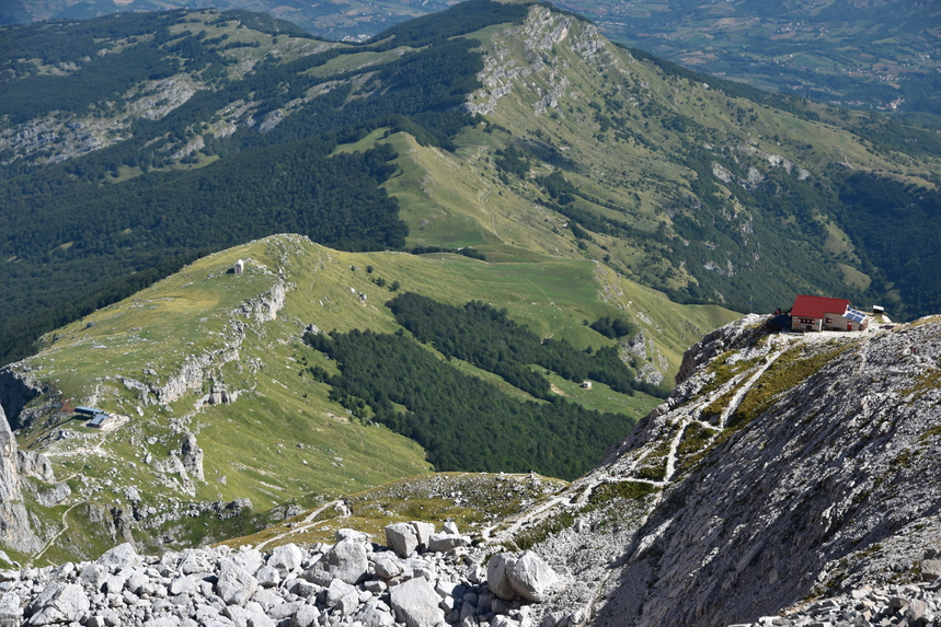
From the arrival of the cable car (named "La Madonnina" after a statue of the Virgin Mary nearby) start walking uphill on the evident path. Both 'horns' (Corno Grande and Corno Piccolo) of the Gran Sasso form a stunning view that will keep you mesmerized (fig. 1). You will also be able to see the southern section of the range and, on a clear day, the Adriatic Sea. After only a few minutes, you will get to a point where a smaller path leads off to the right - make sure you stay on the main path, as the smaller one leads to a beautiful "via ferrata" which you want to avoid for now. After about 20 minutes you will get to a natual arch formed by two boulders resting on each other. A further few minutes on, there is a slightly more difficult (but very short) passage, with a steel cable to help you walk past it easily (fig. 2). The path steepens a bit when it winds its way up to reach the Rifugio.
Stage 2: from the Rifugio Franchetti to the Sella dei Due Corni (15-25 minutes)
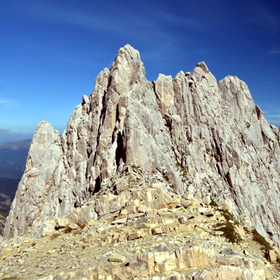
From the rifugio (fig. 3), take the path uphill right in front of it, leading up to the col between the two 'horns'. Until early summer, you're likely to have to walk across patches of snow in this section. Shortly before the col, there is a fork, right to the Corno Piccolo, left to the Corno Grande (both directions clearly marked) – go left (fig. 4). When you reach the col, stop to admire the views. The vertical spires of sheer rock of the Corno Piccolo (known as "fiamme di pietra" / "flames of stone") form an ideal photo background (fig. 5). From here you can also see the rifugio down below, as well as the path to it that you walked on earlier.
Stage 3: from Sella dei Due Corni to Passo del Cannone (20-30 minutes)
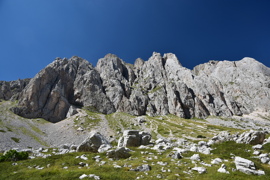
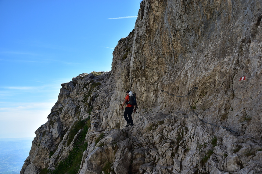
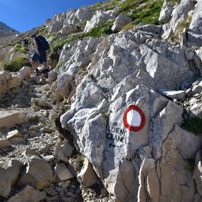
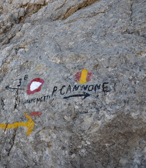
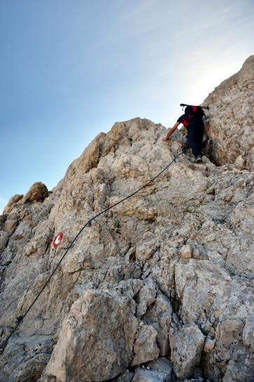
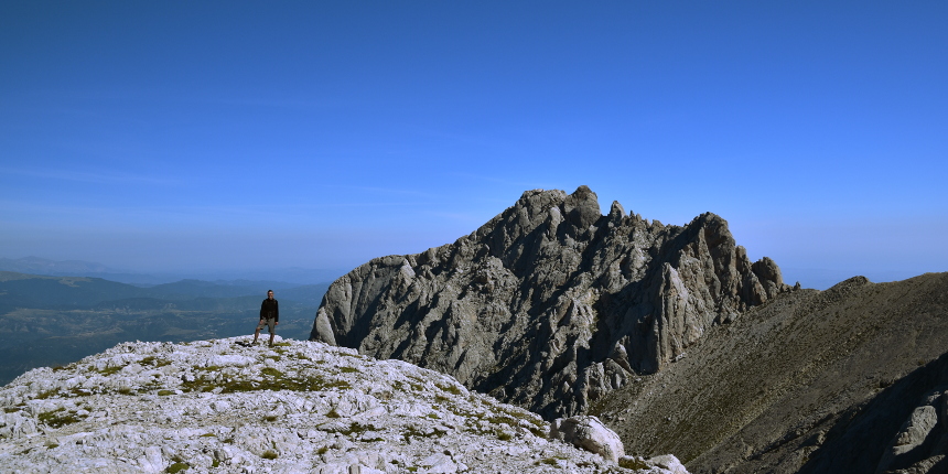
This is the hardest part of the walk. With Corno Piccolo behind you, take the path upwards initially bending slightly to the left and then leading you steeply up the mountain face via a series of hairpins. The terrain is all scree and rock and the path is not always evident, so make sure you always follow the red-and-white marks. Within minutes, you will notice a minor path branching off to the left – ignore it and keep following the marks leading clearly upwards. After about 15 minutes you will get to a point where the scree disappers, revealing a section of bare rock to negotiate. You'll need to scramble your way up here, but it isn't too difficult or exposed. Soon afterwards you'll see a right arrow on the rock indicating the direction to Passo del Cannone (fig. 7). A few steps later, you'll get to a short section equipped with a steel cable, which will help you climb almost vertically for about 10 metres (pay attention here, especially as one or two of the nuts holding the cable have become detached from the rock) – this is Passo del Cannone, the highest point of this walk at 2,698 metres above sea level (fig. 8).
Stage 4: from Passo del Cannone to Sella del Brecciaio (30-45 minutes)
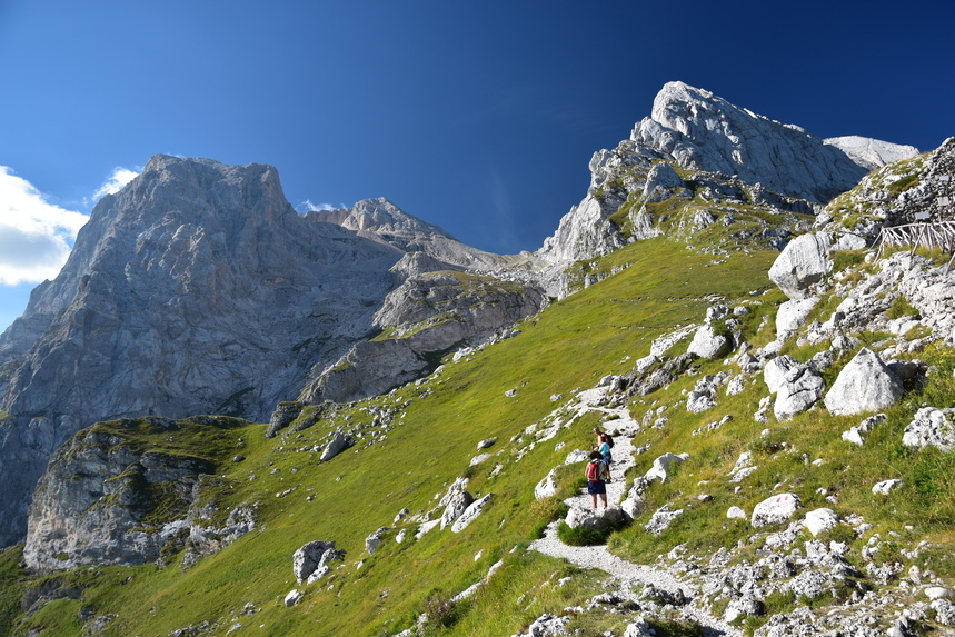
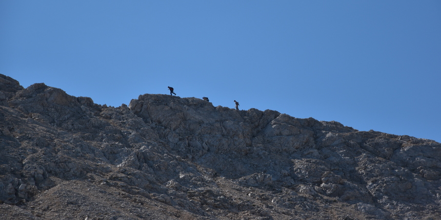
Once you've gone past Passo del Cannone, you're on easy ground again. Most people here continue up to the summit (south), more than 200 metrres higher, but the path you'll follow goes right (south-west) and virtually flat, to join, in a few minutes, the "via Normale" (easiest route to the summit) coming from Campo Imperatore. Once you're on the "via Normale", continue downhill until you reach an outcrop from which the path veers left. This is the Sella del Brecciaio. As you walk down, the "via delle Creste" (a more demanding and aereal route to the summit, fig. 9) is well visible running almost parallel to your left. On your right, you'll see Corno Piccolo (fig. 10) and, more to the left, Pizzo Intermesoli.
Stage 5: from Sella del Brecciaio to Rifugio Garibaldi (30-45 minutes)
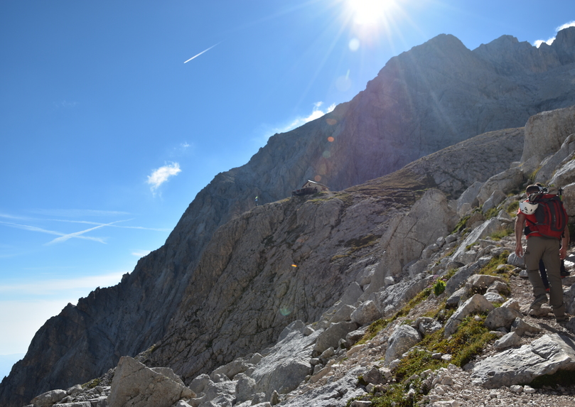
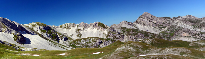
From Sella del Brecciaio, continue on the same path to the left, snaking its way down initially steeply and then more gently, cutting the mountain face in the middle. Depending on the time of the year and day of the week, you're likely to meet many other people here, as they make their way up to the highest peak in the Apennines. The valley of Campo Pericoli is on your right, encircled by the ridge from Monte Portella to Pizzo Cefalone and Pizzo Intermesoli (fig. 11). After 20-30 minutes, leave the main path (and the crowds) and take a smaller path going downhill to the right. This will take you to the heart of wild Campo Pericoli, where the Rifugio Garibaldi is located. The rifugio is hardly ever open, so don't count on it for water or any other provisions. A room with a few camp beds (no mattresses) is always open, however.
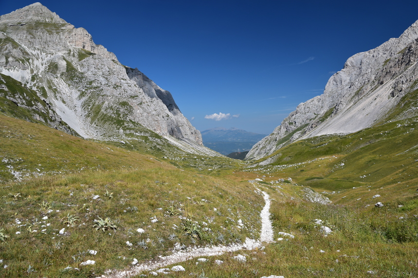
Stage 6: from Rifugio Garibaldi to Prati di Tivo (1 and ¾ hours - 2 and ½ hours)
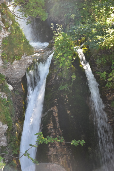
This is by far the easiest section of the walk. From the Rifugio Garibaldi, continue downhill south-west towards the valley bottom of Val Maone. In about 10 minutes you'll get to a crossroads with an old CAI signpost indicating directions to Passo Portella, Val Maone and back to the rifugio. Take the Val Maone route (also signposted "Prati di Tivo") and continue downhill westwards until you reach the valley bottom, where the path veers north, passing between Pizzo Intermesoli to the left and Corno Piccolo to the right. In the horizon, in the middle, are the "twins" Montagna di Campli and Montagna dei Fiori, located half way between the Apennines and the Adriatic Sea (Fig. 12). As you walk further down the valley, the rock face of Pizzo Intermesoli becomes surprisingly dramatic, imposing and daunting, offering good challenges to serious climbers, as an alternative to the more famous Corno Piccolo on the opposite side. Continue along the path and you will see a wooded area in front of you. Just before you reach the trees, you'll hear the sound of water: you've reached the springs of the Rio Arno, where you can get refreshed and fill your water bottles. A few minutes further down and into the trees, you can admire the small but pictoresque waterfalls formed by the same stream. From here to Prati di Tivo it's a half-an-hour walk, some if it uphill. Once you get to the road, it's 5 minutes back to the cable car station.